

The suitable distribution area of artichoke (Cynara scolymus L.) in the Hoang Lien Son Mountain range (Lao Cai Province)
- Department of Ecology, VNU University of Science, No.334 Nguyen Trai str., Thanh Xuan district, Hanoi
Abstract
Hoang Lien Son is a high, rugged mountain range in the northwest region of Vietnam where many ethnic minorities gather, and due to socioeconomic characteristics, the life of the people here still faces many difficulties. Artichoke is a medicinal plant with high economic value and favorable growth in temperate climates and is one of the options for sustainable economic development for people in mountainous areas. The study used a multicriteria analysis method on AHP to analyze the influence of ecological factors of the Hoang Lien Son area (Lao Cai Province) on the growth and development of artichokes. The weights from the AHP model are used to establish ecological adaptation maps through geographic information system (GIS) software. The research results show that the most suitable areas (S1 and S2) for the development of artichokes have an area of 125,642.72 hectares, accounting for 34.41% of the study area. However, the area with the highest adaptability (S1) for growing artichokes is not large, located at an altitude of over 1000 m, mainly at 1700 m in the territory of Sapa town and some communes in Bat Xat district. The results provide the scientific basis for planning potential planting areas and exploiting and developing artichokes to improve livelihoods and people's lives, contributing to biodiversity conservation and sustainable development.
INTRODUCTION
TheHoang Lien Son mountain range, belonging to Lao Cai Province, is an area where many ethnic groups live together, such as Kinh, Dao, Mong, Ha Nhi, and Tay1. Here, economic activities are mainly agro-forestry, but due to low education levels and rudimentary and outdated farming techniques, people still face many difficulties2. Therefore, economic development (with agriculture and forestry as the top development priority) becomes an urgent and meaningful task not only with stabilizing security and social order in the locality but also to protect regional biodiversity.
Artichoke (Cynara scolymus L.) is an herbaceous perennial native to southern Europe (Mediterranean region)3, 4. Currently, artichokes are grown mainly in France, Italy, Spain, the USA and Argentina5. Artichokes were brought to Vietnam by the French in the early 20th century and grown in areas with cool climates such as Sapa (Lao Cai), Tam Dao (Vinh Phuc), Da Lat (Lam Dong)... 6. Not only used as a vegetable, artichoke is also known as a precious medicine and is effective in the treatment of diseases related to circulation, liver, bile, excretion, etc. 7. This species can be harvested in a short time and has high economic efficiency and is one of the important options for poverty reduction.
Integrating remote sensing and GIS technology with multicriteria assessment and decision-making methods such as AHP through domestic and foreign studies plays an important role in identifying suitable areas and analyzing the suitability of the area for agricultural development8. Therefore, this study was carried out with the following objectives: z1) Establish an artichoke ecological adaptation table with ecological factors by determining the characteristics of climate and soil resources in the Hoang Lien Son area and the biological and ecological characteristics of artichokes; (2) Identify the hierarchy of major ecological factors affecting artichokes through the AHP model; and (3) Establish and synthetically assess the ecological adaptation map of artichokes in the study area. The study will provide a scientific basis for proposing a master plan to develop this species in the Hoang Lien Son area (in Lao Cai Province) to improve livelihoods, improve living standards, and contribute to biodiversity conservation.
MATERIALS AND METHODS
Research object: Biological and ecological characteristics of Artichokes (Cynara scolymus L.) in relation to the bioclimate and soil factors
Research area: The Hoang Lien Son mountain range in Lao Cai Province (Figure 1) is limited by the Red River flowing in the northwest-southeast direction, located in the territory of Van Ban, Sapa, Bat Xat districts, part of Bao Yen District, Bao Thang and Lao Cai city.
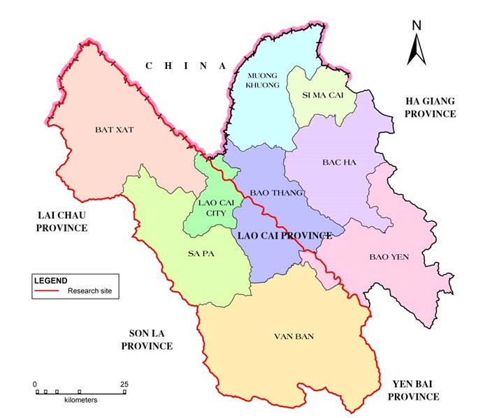
Location map of research area in Lao Cai Province
Research methods:
- Collect and analyze hydrometeorological data: Climatic indicators are collected and statisticalized on the basis of hydrometeorological data from meteorological stations in the Hoang Lien Son area and according to the bioclimatic charts of Vietnam and data stored at the National Center for Hydrometeorology9, 10. The data are arranged and systematized into tables, and the average values, extreme values, and adaptive values are calculated.
- The map of soil distribution and the properties and characteristics of each soil type are analyzed and synthesized from the document Master plan on agricultural development in Lao Cai Province to 2020, oriented to 2030 2. In addition, the physical and chemical criteria of the soil in some potential areas were analyzed at the Laboratory of Ecology and Environmental Biology, VNU University.
- The biological and ecological characteristics of artichokes were collected, analyzed and synthesized from documents: Vietnamese medicinal plants and herbs7, Dictionary of Vietnamese medicinal plants11, Checklist of plants in Vietnam12, medicinal plants13, medicinal plants, remedies and brand-name drugs14. These characteristics were tested and compared with the results of surveys, interviews and actual records on the artichoke farms in Sapa (Lao Cai province).
- Field investigation process applied according to the method of Nguyen Nghia Thin15. Socioeconomic data (population, area, output, incomes...) are collected by the method of interview and participatory sociological survey (PRA) 16.
- Steps to assess the ecological adaptation of artichokes to ecological factors are applied according to the AHP hierarchical model introduced by Saaty (Figure 2)17. This is the method used to make, select, order the indicators and make the final decision. Thirteen factors were selected from 4 groups of criteria, including climatic conditions, soil physical conditions, field construction conditions, and soil nutrient conditions. These criteria are compared in pairs according to the priority on a scale of 9 to determine the indicator with the highest eigenvalues17.

Procedure for determining weights using the AHP method
- The formula used to evaluate the overall ecological adaptation of artichokes to each type of bioclimate:
where S is the index adaptation (S1, S2, S3, N); Mi is the coefficient of adaptation to the criteria (3, 2, 1, 0); Wi is the weight of the indicators.
- The application of a geographic information system (GIS) allows the construction of spatial analysis, management, integration and overlapping of information layers18 to create a map of ecological adaptation of artichokes at the research site through the following steps: (1) inputting and adding data, (2) managing and organizing data, (3) processing and analyzing data, and (4) publishing output data 19.
RESULTS
Characteristics of climate and soil resources in Hoang Lien Son (Lao Cai Province)
Hoang Lien is characterized by an almost year-round climate that maintains a humid state, in particular:
- Radiation and sunshine: Due to its intratropical location, radiation in the Hoang Lien Son area is abundant, with an average of 1400 to 1900 hours of sunshine per year, usually concentrated in April and May and the lowest in February.
- Temperature: The average annual temperature in the study area varies between localities due to the difference in altitude; high mountain areas (Hoang Lien Son, Sapa) usually do not exceed 16°C, and areas at lower altitudes (Lao Cai City, Van Ban) can be approximately 20 degrees. The average temperature difference between the winter and summer months is approximately 10-12°C. The temperature here is not high and uneven with summer - quite high temperature, winter - low temperature, day temperature range is large. The thermal regime in Hoang Lien Son is quite complicated due to the influence of the monsoon mechanism, and there is a large, nontropical differentiation due to the impact of high mountain topography.
- Rain: The average annual rainfall in Hoang Lien Son is quite large, approximately 1400-2800 mm/year, and unevenly distributed in both location and time. The rainy season lasts from April to October, accounting for 70-80% of the annual rainfall, and the maximum rainfall usually falls in August and September. The center of heavy rain is concentrated in Hoang Lien Son - Sapa with rainfall over 2400 mm, even up to 3000 mm/year. In winter, the polar air mass is often blocked on the eastern slope of the Hoang Lien range and persists for many days, causing persistent rain throughout the region. With this rain regime, Hoang Lien Son is very favorable for the development of moisture-loving crops, adapted to the distinct seasonality. The distribution of rainfall in space and time also creates the biodiversity of crops.
- Humidity: Hoang Lien Son is an area with high relative humidity, average from 80 to 90%. The humidity of the area is relatively stable, with little difference between the summer and winter months or between the lowlands and the highlands. Humidity in the highest month is usually above 90%; in the lowest month, the humidity is also close to 80%. As can be observed, the air humidity here is relatively high, and there is no dry phenomenon, creating favorable conditions for the development of crops.
- Soil resources: Soil in the Hoang Lien Son area is differentiated according to the law of high land, including all four land types: low mountain red–yellow feralit soil (below 700 m), medium-mountain red–yellow humus soil (700-1700 m), high mountain alite humus (1700-2800 m) and high mountain peat coarse humus soil (above 2800 m). Based on soil forming factors, referring to Vu Tu Lap's soil classification system20, seven main soil types in the Hoang Lien Son area were identified, including yellow–red ferralite soil, red–yellow soil modified by rice cultivation, red–yellow humus soil (on acid magma and metamorphic rock), alite humus in the high mountains, coarse peat soil on high mountains, alluvial soil in streams and sloping soil.
The Hoang Lien mountain range has a complex topography, which leads to the climate regime of this area being strongly differentiated by altitude and terrain direction. However, this strong differentiation creates favorable conditions for the cultivation and development of plant ecological diversity, especially medicinal plants.
Biological and ecological characteristics of Artichokes
- Biological characteristics: Artichoke is a low tree, nearly 1 m to 2 m high, with white hairs similar to cotton on the stem and leaves.; leaves large, long, alternate, leaf blade deeply lobed, spines, lower surface white, upper surface green, petiole large and short, leaves 1-1.2 m long, 50 cm wide; inflorescence head-shaped, light purple, approximately 8-15 cm; the bracts of the inflorescence are thick and pointed, and the lean base of the bracts and base are edible; the fruit is smooth, dark brown with a white hairy crest, the fruits stick together in a ring, easy to separate when the fruit is ripe; seed without endosperm. Artichoke belongs to the group of C3 photosynthetic plants. Under warm conditions, in the tropics, artichokes can be grown at altitudes above 1500 m. The tree has an economic cycle of 5 years, and the highest yield is reached in year 3.
- Ecological characteristics: Artichokes do not tolerate cold, are only suitable for cool climates, and are most suitable for growth in mountainous areas (maximum altitude below 2000 m) with average temperatures of 15-25°C. In addition, it can also be grown in the plains at a temperature of 25-30°C. Above 30°C, the artichoke plant will stop growing. Artichoke does not require high rainfall; the annual rainfall is in the range of 300-1500 mm, and the most suitable is in the range of 900-1200 mm. Artichoke is suitable for soil with pH values from 5.5 to 8.3, of which the most suitable is 6-6.5. The soil layer is approximately 50-150 cm thick. The soil texture ranges from light to heavy, of which the most suitable are light and medium. The nutrient condition of the soil should have medium to high fertility, expressed through parameters such as total N, total P, digestible N, digestible K, and CEC. Soil salinity below 4 dS/m and the need for well-draining soil are indicated by the Gley level of the soil. In fact, in cultivation and care, people find that artichokes are less affected by other factors, mainly adversely affected by excessive rainfall on seed planting or negative weather phenomena such as hail. The plant has few pests and diseases. The main pests, such as fungi, aphids, and worms, are in the young period, but they are easy to prevent and have little effect on the yield of artichokes.
The degree of ecological adaptation of artichokes
Establishment of the artichoke ecological adaptation table with ecological factors
The ecological adaptation threshold of artichokes to ecological conditions in the Hoang Lien Son area (
Ecological adaptation table of artichokes to ecological factors in the study area.
|
Ecological factor |
Symbol |
Value |
Unit of measure |
Explanation |
Adaptation level | |||
|
High |
Medium |
Low |
No | |||||
|
S1 |
S2 |
S3 | ||||||
|
a. Weather condition | ||||||||
|
1. Average annual rainfall |
m |
<2000 |
mm/year |
Average |
+ | |||
|
l |
2000 – 2500 |
High |
+ | |||||
|
vl |
>2500 |
Very High |
+ | |||||
|
2. Average annual temperature |
1 |
<12 |
oC |
Very Cold |
+ | |||
|
2 |
12 – 16 |
Cold |
+ | |||||
|
3 |
16 – 20 |
Cool |
+ | |||||
|
4 |
>20 |
Warm |
+ | |||||
|
3. Cold season length |
3 – 4 |
Number of cold months |
Average |
+ | ||||
|
m |
5 – 7 |
Long |
+ | |||||
|
h |
8 – 11 |
Very long |
+ | |||||
|
vh |
12 |
Year round |
+ | |||||
|
4. Dry season length |
<3 |
Number of dry months |
Short |
+ | ||||
|
m |
3 – 4 |
Average |
+ | |||||
|
h |
5 |
Long |
+ | |||||
|
b. Soil physical condition | ||||||||
|
5. Soil thickness |
x |
>100 |
cm |
Thick |
+ | |||
|
y |
50 – 100 |
Average |
+ | |||||
|
z |
<50 |
Thin |
+ | |||||
|
6. Soil mechanical composition |
Mixed sand |
+ | ||||||
|
c |
Light soil |
+ | ||||||
|
d |
Average soil |
+ | ||||||
|
c. Conditions for field construction | ||||||||
|
7. Slope |
1 |
0 – 8 |
Degree |
Flat |
+ | |||
|
2 |
8 – 15 |
Less slope |
+ | |||||
|
3 |
15 – 25 |
Average |
+ | |||||
|
4 |
>25 |
High |
+ | |||||
|
d. Soil nutrient conditions | ||||||||
|
8. N total |
l |
<0.1 |
% |
Poor |
+ | |||
|
m |
0.1 – 0.2 |
Average |
+ | |||||
|
h |
>0.2 |
Rich |
+ | |||||
|
9. P total |
vl |
<0.03 |
% |
Very Poor |
+ | |||
|
l |
0.03 – 0.06 |
Poor |
+ | |||||
|
m |
0.06 – 0.1 |
Average |
+ | |||||
|
h |
>0.1 |
Rich |
+ | |||||
|
10. Digestible N |
l |
<5 |
mg/100 g soil |
Poor |
+ | |||
|
m |
5 – 10 |
Average |
+ | |||||
|
h |
>10 |
Rich |
+ | |||||
|
11. Digestible K |
l |
10 |
mg/100 g soil |
Poor |
+ | |||
|
m |
10 – 20 |
Average |
+ | |||||
|
h |
>20 |
Rich |
+ | |||||
|
12. CEC |
l |
10 |
mg/100 g soil |
Low |
+ | |||
|
m |
10 – 20 |
Average |
+ | |||||
|
h |
>20 |
High |
+ | |||||
|
13. Gley |
l |
Non |
+ | |||||
|
m |
Weak |
+ | ||||||
|
h |
Moderate to strong |
+ | ||||||
Hierarchy of major ecological factors
The main factors affecting the ecological adaptation of artichokes in the study area were calculated in correlations using the AHP model through weighted values (
Weight table of factors affecting the ecological adaptation of artichokes.
|
Criteria |
Average annual rainfall |
Average annual temperature |
Cold season length |
Dry season length |
Soil thickness |
Slope |
N total |
Soil mechanical composition |
P total |
Digestible K |
CEC |
|
Weight value |
0,18 |
0,19 |
0,08 |
0,07 |
0,05 |
0,04 |
0,14 |
0,02 |
0,10 |
0,08 |
0,05 |
With a consistent ratio value (CR) = 0,06 < 0,1, consistency in the evaluation process is guaranteed. The results of multicriteria analysis for 11 groups of factors show that the annual average temperature and the average annual rainfall have the greatest influence on the ecological adaptation of artichokes, with weights of 0.19 and 0.18, respectively.
Synthetic assessment of the ecological adaptability of Artichokes
The eco-adaptation map of artichokes (Figure 3) with high suitability area (S1), medium suitability area (S2), low suitability area (S3) and not suitability area (N) was established by ArcGIS software based on a synthetic evaluation formula combined with weights of key ecological factors.
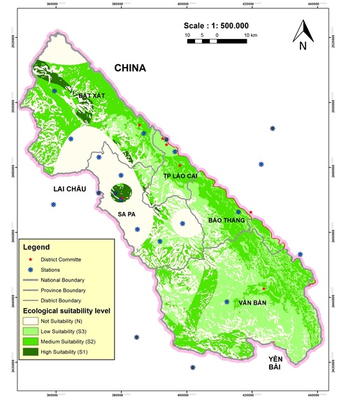
Map of the ecological adaptation of artichokes in the Hoang Lien Son area.
The total acreages of each area (Figure 4) show that the high suitability area (S1) and medium suitability area (S2) had 30% of the area in the research site, and the rest was a low suitability area (S3) and not suitable area (N).

Area chart of ecological suitability zones of artichokes in the Hoang Lien Son
The result from the softwave shows the following:
- High suitability area (S1) has a total area of 8,857.14 ha, accounting for 2.43% of the area, distributed in Sapa town, San Sa Ho, Sa Pa, Trung Chai and Thanh Kim communes in Sapa district; A Lu, Ngai Thau, Trinh Tuong, Coc My, Den Thang, Phin Ngan communes in Bat Xat district. In these areas, the soil is mainly red–yellow humus on clay mountains or pale-yellow humus in the mountains with a temperature between 13°C and 19°C. In fact, Sapa district has put artichokes in the group of 4 main medicinal plants, planted on 70 ha per year, on average harvested more than 3000 tons of fresh leaves with a revenue of nearly 8 billion VND/year. In Bat Xat district, the main area of artichokes is planted by people in groups of households in villages and hamlets.
- Medium suitability area (S2) has a total area of 116,785.58 ha, accounting for 32% of the area, mainly distributed in the communes of Y Ty, Den Sang, Den Thang, Sang Ma Sao, Trung Leng Ho, Trinh Tuong, Coc My, Ban Vuoc, Bat Xat townships and Phin Ngan communes of Bat Xat district; Ban Ho and Nam Cang communes of Sapa district; Lao Cai city; Phong Hai, Phong Nien and Pho Lu communes of Bao Thang district; Vo Lao, Tan Thuong, Tan An, Khanh Yen, Chieng Ken, Nam Tha, Dan Thang, Minh Luong, Nam Xay communes of Van Ban district; Cam Con commune in Bao Yen district. In these areas, the soil is mainly red–yellow feralit soil, yellow–red humus soil, and light yellow humus soil. The limiting ecological factors here are rainfall and terrain slope. In fact, in the survey, only scattered households growing artichokes were found without recording concentrated growing areas. However, the communes in the appropriate area (S2) are potential communes that can expand the local artichoke growing area.
- The low suitability area (S3) has a total area of 104,102.38 ha, accounting for 28.5% of the area, mainly distributed in Van Ban district and scattered in the remaining districts. In these areas, the soil is mainly red–yellow ferralic soil and yellow–red humus on acidic magma. The limiting ecological factors here are rainfall and soil nutrients.
- Not suitable area (N) has a total area of 135,354.38 ha, accounting for 37.07% of the area, in the area of A Mu Sung, Nam Chac, Nam Pung, Pa Cheo communes of Bat Xat district; Ta Giang Phinh, Ban Khoang, Ta Phin, Lao Chai, Ta Van, Thanh Phu, and Suoi Thau communes of Sapa. In these areas, the soil is mainly red–yellow soil, red–yellow humus soil, and light yellow humus soil on high mountains. The limiting ecological factors here are the length of the dry season and the length of the cold season.
DISCUSSION
Following the purpose of researching the cultivation of artichokes in the Hoang Lien Son area (Lao Cai Province) to ensure high economic efficiency on the basis of adapting to natural conditions, the study evaluated and analyzed 13 ecological factors in 4 groups of indicators (weather conditions, soil physical conditions, field construction conditions, and soil nutrient conditions). Based on the biological and ecological characteristics of artichokes, the average annual temperature and average annual rainfall are the two main factors affecting the ecological adaptation of artichokes. The study also shows that the weather and soil conditions in the Hoang Lien Son area (Lao Cai Province) are quite favorable for the cultivation and development of artichokes, with over 30% of the area being assessed as suitable and very suitable for a total area of 125,642.72 ha, mainly distributed in Sapa, Bat Xat and Lao Cai city.
With previously published studies on artichokes in Vietnam mainly focusing on chemical composition and pharmacological properties, this can be considered the first study on ecological adaptation and planning of growing areas of artichokes in a local area. Therefore, this study lacks comparisons and contrasts with the cultivation of artichokes in other locations. However, it is also a new direction in the next research steps to expand the growing area for artichokes in areas that have similar weather and soil conditions or to compare and contrast the differences in ecological factors affecting the growth and development of artichokes in different areas.
Furthermore, compared with other medicinal plants of high economic value in the same area of Hoang Lien Son that we studied, such as Panax pseudoginseng 21, Fallopia multiflora, Codonopsis javanica, Stephania glabra, Angelica sinensis, Cynara scolymus, can be grown right in the garden or in areas close to people's living places, especially in large cities and towns of Lao Cai province, with more convenience for cultivation, harvesting and transportation. Through the results of sociological surveys conducted in the local area, 90% of the people chose artichoke as 1 of the 5 medicinal plants they wanted to farm, and 75% of the people interviewed confidently chose artichoke as a plant they had enough experience or knowledge to farm. Through agricultural extension channels and information from other farmers, people understand that artichoke is a plant of high economic efficiency with not too much investment capital, has higher profits than other plants in the same cultivation area, is fast to harvest but is not difficult to take care of. In addition, pharmaceutical companies such as Traphaco are building headquarters, factories, and consuming all products with a committed price of 2,200-2,500 VND for 1 kg of fresh leaves (for 5 consecutive years), while 1 hectare per year can collect from 40-50 tons of fresh leaves, not to mention that each individual plant produces 5-6 flowers when harvested with a market price of 100,000 VND/kg (approximately 2 flowers for 1 kg of artichoke). These factors have created a dynamic in the effort of people to continuously expand the area of artichoke cultivation, making it a key medicinal plant with an annual raw output accounting for 50% of the raw medicinal output harvested in the province. Being able to rotate artichokes with legumes, crops, and vegetables and being able to use all parts of artichokes is also a strong point of this medicinal plant.
The research is practical and highly scientific in the context of the locality, providing information on the biological and ecological characteristics of artichokes as well as potential planting areas in the province for local people and management, planning and policy units. This will help to plan and optimize the development and growth of artichokes, create efficient exploitation, revolve capital and improve incomes for people, promote security, enhance livelihoods and reduce local poverty. Moreover, this will promote the transformation from scattered and spontaneous farming to large-scale specialized farming, relying on science and technology to avoid rampant and nonplanning farming and avoiding the waste of resources and material.
This study creates a premise for the locality to continue doing research focusing on planning suitable areas where artichoke cultivation can be expanded and building concentrated artichoke growing areas in communes. Initially, it is advisable to conduct research to expand the farming area, provide technical advice to people, conduct business connections to ensure output, and then focus on enhancing quality and sustainable development. Therefore, the livelihoods of people in communes, especially poor communes in the province, will be improved.
CONCLUSIONS
Hoang Lien Son is an area with complex terrain and climate with strong differentiation in space and time, which creates favorable conditions for the development of plant biodiversity, especially medicinal plants.Of the 11 major ecological factors evaluated, the annual average temperature and the average annual rainfall factor have the greatest influence on the ecological adaptation of artichokes, with weights through the AHP model of 0.19 and 0.18, respectively.The most suitable area (S1 and S2) for artichoke development has an area of 125,642.72 ha, accounting for 34.41% of the study area. The area with high adaptability (S1) for growing artichokes is small, located at an altitude of over 1000 m, mainly at an altitude of 1700 m in the territory of Sapa town and some communes of Bat Xat district. Areas with lower levels of adaptation are mainly located at altitudes of 300 - 1000 m. In fact, the area under cultivation and planning for artichoke growing in the appropriate area (S1 and S2) is relatively small, although artichokes give great economic value, ensure livelihoods and stabilize lives for people. Therefore, based on these potentials, the locality can continue to expand the farming side in the appropriate area.
LIST OF ABBREVIATIONS
GPS: Global Positioning System
AHP: analytic hierarchy process
COMPETING INTERESTS
We declare that we have no conflicts of interest.
AUTHOR CONTRIBUTIONS
The entire content of the article is done by authors only. Kiem T.N. designed the model and experiment, performed statistical analyses, wrote the first draft of the manuscript; Cong N.N. conducted the experiment and collected data under the supervisions of Kiem T.N. All authors contributed to the later version of the manuscript, read and approved the manuscript for publication.